
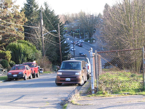
There are a few changes from the 1956 photo to today, though the site is still clearly recognizable. This is just north of where Columbian Way carries the I-5 and West Seattle Bridge ramp traffic up toward Beacon Hill.
In the 1956 photo, there are much fewer trees and plants than we see in the modern view. The empty lot on the left side of the old photo is now the big apartment building at Columbian and Spokane, though it’s hidden behind trees in the new photo. The Columbian/Spokane intersection is rather busy now, but there’s no obvious traffic signal there in the 1956 photo.
The sidewalk on the right side of 14th no longer exists; the space is now blocked by a chain-link fence. And the car turning right onto Columbian at the bottom of the hill is doing something that is no longer legal; 14th is a one-way street going northbound in this area now. However, while I was taking the current-day photo, a car sped past me, down the hill, and took the right turn anyway.
Here’s another 1956 photo of this location:


Thanks for the “then and now” photos! A lot changes in 50 years.
BTW, If you live in this area and want to give friends directions, tell them to use Mapquest when coming from the freeway exit to Columbian Way. After the Freeway exit, Yahoo, Google (and maybe others) give directions to someplace on planet Mars.
Read these confusing Google directions to get to S. Hanford St.:
9. Take exit 163A for Columbian Way 0.5 mi
10. Merge onto Seattle Fwy 0.2 mi
11. Slight right at 14th Ave S 203 ft
12. Turn left at S Spokane St 79 ft
13. Turn left at S Columbian Way 187 ft
14. Slight right at 14th Ave S 0.2 mi
15. Turn left at S Hanford St 0.1 mi
And Yahoo’s version:
Take exit #163A/W SEATTLE BR/COLUMBIAN WAY onto COLUMBIAN WAY S toward 15TH AVE S – go 0.60.9 mikm
Bear Right on 14TH AVE S
Turn Left on S SPOKANE ST
Turn Left on S COLUMBIAN WAY
Bear Right on 14TH AVE S – go 0.30.4 mikm
Turn Left on S WINTHROP ST – go 0.10.2 mikm
Turn Left on 12TH AVE S
Huh???
Also, many people’s GPS units tell them to turn left from Columbian Way onto S. Spokane St. eastbound, then to make an immediate left turn onto 14th Ave S., which is not only illegal (Double Yellow Line), but extremely dangerous, due to the limited sight distance of speeding cars coming westbound on S. Spokane St.