Tag Archives: greenways

Opinion: Greenway improvement at Beacon/Hanford hazardous, unnecessary

A car crosses Beacon illegally at the Hanford/Beacon intersection, which was recently revised to “right turn only” for cars going east/west. Photo by Wendi Dunlap/Beacon Hill Blog.
By George Robertson

I drove the length of the Beacon Hill Neighborhood Greenway from the freeway to Jefferson Park on April 7. It was parallel to my usual route and I was curious. There were no bikes anywhere to be seen on the Greenway, but I did see two bicyclists pass northbound on Beacon Avenue when I was parked for a minute or two at South Hanford Street and Beacon Avenue South contemplating what to do about a traffic revision blocking my path. I could have chosen backing up a block and illegally around a corner to get back onto 18th, after discovering that anyone headed for Victrola on the opposite side of Beacon Avenue now needs to make a right turn, a U-turn, and another right turn to get across Beacon Avenue on Hanford Street. I’ll use my Fifth Amendment right to deflect any questions about which option I chose to find a route across the street.

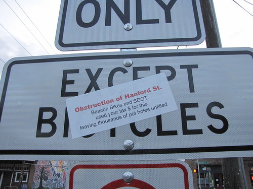
The car counts and traffic history of the intersection at Beacon Avenue South and South Hanford Street prior to the recent “improvement” have been normally uneventful, and there is simply no reason for obstructing any normal vehicular access in any direction to continue safe bicycle use at that intersection. Yet we see a river of money being wasted there inconveniencing and endangering the high frequency of bicyclists using that intersection bound north-south on Beacon Avenue South, in favor of nearly mythical bicycle usage frequencies east-west on South Hanford Street.

The newly created islands at Beacon and Hanford are a hazard to bicycle traffic. They create a choke point in the north-south traffic flow on Beacon Avenue. There are north- and southbound bus stops in both curb lanes of Beacon Avenue South at South Hanford Street. The new concrete traffic islands squeeze all north- and southbound through traffic into a much narrower than usual lane width on either side of the concrete island. The new concrete islands block and occupy what used to be, and is everywhere else, the relatively traffic-free safe refuge area provided by a continuous two-way center left-turn lane. The hazard that represents to bicyclists on Beacon Avenue South should have been sufficient reason to prevent the islands from ever being built. But it did not. Now if we want to prevent inevitable injury at that intersection, we are faced with having to overcome the inertia of embarrassed SDOT engineers to remove the three recently built left-turn-lane-blocking islands there. I hope that public opinion will help that process move swiftly.

The needless disruption of normal turning movements of automobile traffic into and out of the neighborhoods east of Beacon Avenue South from and across Beacon Avenue, both westbound and eastbound, should motivate residents there to call for remedial action. When you consider that South Hanford Street is the only street connecting with Beacon Avenue South that goes east of 19th Ave S. between South Spokane Street and South Stevens Street, interfering with left turns southbound on Beacon Avenue South represents a very significant disruption of normal traffic in and out of a very large neighborhood area east of Beacon Avenue for hundreds of families every day. Rerouting daily east-west trips on South Hanford that would go left or cross Beacon Avenue, to South Stevens Street or onto the already overloaded Spokane Street unfairly burdens their neighbors living on the South Stevens Street route with the displaced traffic. The new median islands and traffic restrictions at Beacon Avenue South and South Hanford Street are, unsafe and are frankly ridiculous traffic engineering overkill. Bicycles and bicyclists as a special interest group do need to be accommodated, on every street, but not to the point of reckless endangerment and/or exclusion of other rightful users of the streets.

George Robertson is a Beacon Hill resident of more than twenty years, an architect, an artist, and an occasional writer of self-described “often-incendiary rants that annoy the neighbors.”

Do you have something to say? Send us your own opinion pieces on this or other Beacon Hill-related topics.

Some anonymous neighbor expressed his or her opinion about the revisions at the Beacon/Hanford intersection by stickering one of the new signs there. Photo by Wendi Dunlap/Beacon Hill Blog.

Open house to discuss Neighborhood Greenway

All are invited to a Seattle Department of Transportation open house on Thursday, July 19 from 6:30-8 p.m. at Jefferson Community Center (3801 Beacon Ave. S.) to discuss the Beacon Hill Neighborhood Greenway.

The greenway is a 2.8 mile long pedestrian- and bicycle-friendly route through North Beacon Hill, providing improved access to locations including the I-90 Trail, Beacon Hill Station, Beacon Hill Library, Jefferson Park, Maplewood Playfield, Mercer Middle School, Maple Elementary School, and Cleveland High School.

The route has changed slightly since the earlier proposed version of the Greenway. The current route will start at the I-90 Trail and 18th Avenue South, then continue south along 18th. The greenway will then turn and cross Beacon Avenue South at South Hanford Street, and continue on Lafayette Avenue South into Jefferson Park. The route will continue south of Jefferson Park, crossing 15th Avenue South at South Dakota Street, and continuing on 12th Avenue South to South Lucile Street.

What makes a run-of-the-mill route a neighborhood greenway? Greenways are non-arterial street routes that have improvements to encourage and support safe bicycle and pedestrian use, in combination with reduced auto speeds and volumes. In the case of the Beacon Hill Greenway, these enhanced features have been proposed:

  • Signs and pavement legends along the greenway
  • Stop signs to control traffic crossing the greenway
  • A median island with new marked crosswalks at Lafayette Avenue South and South Spokane Street
  • A median island with new marked crosswalks at Beacon Avenue South and SouthHanford Street
  • Rechannelization and signal improvements at Beacon Avenue South and South Spokane Street
  • A widened sidewalk on South Dakota Street between 16th Avenue South and 14th Avenue South
  • A paved trail adjacent to Jefferson Park


View Beacon Hill Neighborhood Greenway in a larger map

Biking on Beacon: All about trees

Trees previously planted along a Beacon Hill greenway. Photo courtesy of Dylan Ahearn.
Would I please shut up with the bike stuff!?  Why, yes I will.  Let’s talk about street trees!

As noted in this previous post, Beacon BIKES has been working with SDOT to plant trees along our planned Neighborhood Greenway routes.  We had a very successful effort last fall planting 70 trees along 18th Avenue South.  Now we are working with SDOT to plant 300 more trees this March.  The City plants the trees, waters them for three years, and prunes for the life of the trees.  Home owners get to pick among three tree types or choose no tree at all.  It is called the SDOT Community Tree program, and you can find out more about it here.

If you have questions about the program email me or come to the next North Beacon Hill Council meeting (March 6th, 6:30-8:00 pm, Beacon Hill Library) where we will be presenting a little more info.  The planting is scheduled for mid- to late March and we will be planning a community tree planting day to plant a few by hand in the same time frame. SDOT has already marked some of the proposed planting locations; you can check out the flags along 14th Ave S to get a feel for how this program can really improve a street for all users.

If you live north of Lucile and would like a tree or two planted in your planting strip let me know and I will forward it to the City.  If you would like a tree for your yard instead of your planting strip, there is another great City program called Trees for Neighborhoods which has been posted about previously here, with more up-to-date info here.

Biking on Beacon: More Neighborhood Greenways coming to Beacon Hill in 2012

Seattle City Councilmember Sally Bagshaw spoke at the recent Neighborhood Greenways meeting at the Beacon Hill Library. Photo by Dan Bennett.
By the end of 2012 Beacon Hill residents will be able to safely walk or bike from the Mountains to Sound Trail to Georgetown on a quiet and safe residential street optimized for non-vehicular traffic.  First presented in the Beacon Hill Family Bicycle and Pedestrian Circulation Plan, this signed route (mapped here) will include safe arterial crossings at Beacon, Spokane, and Columbian, as well as pavement markings, tree planting, and other safety improvements. The 3-mile route connects six schools (Cleveland, Maple, St. George, Thurgood Marshall, Asa Mercer, and Washington), three major parks (Maple, Jefferson, Judkins), the library, and our business district with a pleasant safe street for you and your family to walk or bike along (of course, cars are still welcome for local residents).

At a January 10 meeting of Seattle Greenway Organizers at the Beacon Hill Library, Seattle City Councilmember Sally Bagshaw enthusiastically announced a set of pilot Neighborhood Greenways being planned by the Seattle Department of Transportation (SDOT) that are designed to make streets safer and more pleasant for people who live, walk, bike, and drive in Seattle’s neighborhoods.

The Neighborhood Greenways under review total 11 miles: seven miles in Ballard, Beacon Hill, Greenwood, North Delridge, Wallingford, and the University District and an additional four miles in Laurelhurst (funded by Seattle Children’s Hospital). These projects are intended to form the backbone of a new network of Greenways that effectively connect people to the places they want to go by giving them a choice to travel on quieter, safer streets around the city.

Signs mark directions on the Neighborhood Greenway at 18th Ave. S. and S. Forest St. Photo by Dylan Ahearn.

Councilmember Bagshaw, chairing the newly formed Seattle City Council’s Parks and Neighborhoods Committee, is excited to include Neighborhood Greenways on her agenda.  “Greenways connect parks and schools, community centers and neighborhood business districts. Neighborhood Greenways help with transportation, and they help with getting people where they want to go within their own communities.” (Watch a YouTube video of Councilmember Bagshaw’s announcement here.) Councilmember Bagshaw and Councilmember Tom Rasmussen, who chairs the Seattle Transportation Committee, have taken great leadership initiative on Greenways.

In case you missed previous posts here and here: Neighborhood Greenways are slow-speed, low-traffic residential streets made even more pleasant for the people who live, walk, and bike on them. By adding new park-like amenities and limiting cut-through traffic, Greenways are naturally attractive both for families, and for anyone seeking a safer, more connected community experience. By placing Greenways a block or two away from major arterials, Neighborhood Greenways create a great option for people who prefer to walk or bike away from congested streets. While many new dedicated walking and bicycling trails are beyond the reach of our City’s budget, 10 miles of Greenways can be built for the cost of a single mile of new trail, offering the potential to bring a high-quality network to all Seattle neighborhoods at a comparatively low cost. Neighborhood access by emergency service vehicles and freight delivery vehicles—and parking—is preserved along Greenways.

If you would like to get involved with Greenway planning on Beacon Hill during these exciting times please visit the Beacon BIKES webpage and come to our February meeting!

Neighborhood greenway organizers meeting on Beacon Hill next Tuesday

This sign was placed on the 17th Avenue South greenway on North Beacon Hill. Photo by Wendi.

A Seattle city-wide neighborhood greenway organizers event will be held on Beacon Hill at the Beacon Hill Library next Tuesday, January 10, from 6-7:45 p.m. Beacon Hill currently has a new greenway in progress along 17th/18th Avenues South, between Jefferson Park and the Mountains-to-Sound Trail. For more information on what neighborhood greenways are all about, see this video about Portland’s greenways project.

Here’s the announcement for next Tuesday’s meeting:

Seattle’s Neighborhood Greenways movement is attracting many newcomers to bike advocacy who are eager to transform Seattle into a city where everyone can bike and walk safely. Come join us to learn about the history of bike advocacy in Seattle, and how our growing Neighborhood Greenways movement can complement the hard work that’s already been done to make Seattle one of the nation’s most respected cities for bicycling and walking.

We are privileged to welcome Blake Trask as our featured speaker for this meetup. Blake is the chair of the Seattle Bike Advisory Board (SBAB) and is the Statewide Policy Director of the Bicycle Alliance of Washington (BAW). He’ll be providing us with the context for Seattle’s current (2007) Bicycle Master Plan: who was involved in it? What was the vision? What were the biggest challenges? And how can Neighborhood Greenways be incorporated into the 2012 update to the Bicycle Master Plan?

Blake brings a wealth of knowledge and many years of experience in improving bike safety “from the inside”. By learning from Blake where we’ve already been as an advocacy movement, we will be even better equipped as Neighborhood Greenways organizers to “work within the system” to make bicycling and walking safe and attractive for all Seattle.

We will also be discussing the upcoming neighborhood project fund grants (deadline Feb 1). This is a great and easy way to get some Greenways built in your neighborhood NEXT YEAR!

Please attend this meeting if you can.

Biking on Beacon: Greenway edition

New wayfinding signage like this is found on the new Beacon Hill Greenway. Photo by kashgroves in the Beacon Hill Blog photo pool on Flickr.
We at Beacon B.I.K.E.S. (Better Infrastructure Keeping Everyone Safe) love us some Neighborhood Greenways.

What are Neighborhood Greenways, you may ask?

Neighborhood Greenways are quiet residential streets that are optimized for pedestrian and bicycle travel. The idea is to have routes that connect our neighborhood to itself along streets that are safe for those 8 to 80 years old. The bike lanes on the arterials are only going to be used by a small minority of the neighborhood; Neighborhood Greenways, on the other hand, can be conformably used by anyone!

What does a Neighborhood Greenway look like?

The best introduction to Neighborhood Greenways is this video from Portland. Basically, a residential street that connects neighborhood destinations is outfitted with wayfinding signs, paint markings on the street (like the “sharrows” on 15th), some traffic calming (speed bumps, traffic circles), improved crossing treatments at intersections with arterials, and maybe some trees to spruce the place up.  The result is a street that gives that small town feel in the middle of the big city. Traffic is calmed where people want it calmed (in front of their homes!), bikers are off the arterials where conflicts with traffic are good for no one, use of the public space provides more eyes on the street and thus reduces the likelihood of crime, and you can bike to the park or to school with your kid without worrying for their lives.

The Beacon Hill Family Bicycle and Pedestrian Circulation Plan is basically a big network of Neighborhood Greenways on Beacon Hill.  The first Greenway route (18th Ave South/17th/Lafayette) is currently being implemented.  The wayfinding signs are up (you may have seen them around the library), the paint will be going in within a month, and as of yesterday SDOT planted about 70 trees along the route. I snapped some photos this morning of our new friends on the hill. Its not a Greenway without the Green, so we are excited that the city agreed to help us out with the trees!  Neighbors along the route with a spot for a potential tree in their planting strip were offered a choice of a couple different species of trees or no tree at all.  SDOT planted and will water the trees for 3 years until they are established.  SDOT will also prune for the life of the trees.  The trees planted were paperbark maples, Persian ironwood, “Royal Raindrops” crabapples, “Native Flame” American hornbeam, and “Emerald Sunshine” elm.

If you get the chance, take a stroll down 18th and see how our first Greenway is coming together!

Next Beacon B.I.K.E.S. meeting is Wednesday November 16th, 6-8pm at the library.  All are welcome!

Greenway signs sprout on 17th and 18th Avenues

New wayfinding sign on the 17th/18th Avenue South Greenway, on 17th Avenue just south of South Forest Street. Photo by Wendi.
New signs appeared along 17th and 18th Avenues South recently, the first visible step toward the new Beacon Hill Greenway, part of a planned network of neighborhood greenways on Beacon Hill. The signs direct cyclists to neighborhood locations such as Jefferson Park and Beacon Hill Station via the greenway route.

Greenways are residential streets that are designed to be safe neighborhood connections for bicyclists and pedestrians, while still allowing automobile access using traffic calming measures. (City Councilmember Sally Bagshaw has posted a FAQ with more information about neighborhood greenways on her website.)

Seattle’s greenways have recently seen a lot of press, including articles in The Seattle Times, Publicola, Seattle Bike Blog, and The Atlantic Cities.

For more information on bicycle and pedestrian strategies on Beacon Hill, see the Beacon Hill Family Bicycle and Pedestrian Circulation Plan, a ten-year plan put together by Beacon B.I.K.E.S. and ALTA Planning + Design. (See also the appendix.)