Tag Archives: pedestrians

Beacon B.I.K.E.S. appeals for greenway support

Beacon B.I.K.E.S. members at the neighborhood greenways group meeting at the Beacon Hill Library in January, 2012. Photo by Dan Bennett in the Beacon Hill Blog photo pool on Flickr.
The folks at Beacon B.I.K.E.S. sent out the following appeal on Facebook yesterday:

Hello Beacon BIKErs,

This is a call to anyone who is on this list that lives on Beacon Hill and wants to see our Greenway be built.

SDOT had a community open house on July 19, I saw many of you there. They collected public comments, many of which were positive. However, there have been a few individuals that have been very vocal in their opposition and their voices are drowning out the broad-based support we have for this project in our community. Please take 5 minutes to write an email showing support for the project to SDOT and Council. I have spoken with key individuals at the City and they say these emails are the single most important thing we can do right now. If you can, add why the project is important to you personally. They have heard from me and a couple other active members many times, to have a really powerful effect it would be wonderful if those of you who have not been very active could write an email.

The details of SDOT’s plan can be found here:
http://www.seattle.gov/transportation/beaconhillgreenway.htm

Address to: Brian.Dougherty@seattle.gov
CC: sandra.woods@seattle.gov, dongho.chang@seattle.gov, sally.bagshaw@seattle.gov, Douglas.Cox@seattle.gov, tom.rasmussen@seattle.gov, dsahearn@gmail.com, and anyone else you want…

Thank you for your help in making Beacon Hill a safer and more livable neighborhood.

The proposed greenway would follow 18th Avenue South from the I-90 trail south to South Hanford street, where it would zigzag over to Lafayette Avenue South, then along the edge of Jefferson Park to South Dakota Street, then south on 12th Avenue South to South Lucile Street. The greenway route would have improvements and repairs to make the street safer for cyclists, drivers, and pedestrians alike, including new signage and street markings, crossing islands at certain intersections, a new left turn lane on South Spokane Street, and others. As mentioned above, details may be found here.


View Beacon Hill Neighborhood Greenway in a larger map

Open house to discuss Neighborhood Greenway

All are invited to a Seattle Department of Transportation open house on Thursday, July 19 from 6:30-8 p.m. at Jefferson Community Center (3801 Beacon Ave. S.) to discuss the Beacon Hill Neighborhood Greenway.

The greenway is a 2.8 mile long pedestrian- and bicycle-friendly route through North Beacon Hill, providing improved access to locations including the I-90 Trail, Beacon Hill Station, Beacon Hill Library, Jefferson Park, Maplewood Playfield, Mercer Middle School, Maple Elementary School, and Cleveland High School.

The route has changed slightly since the earlier proposed version of the Greenway. The current route will start at the I-90 Trail and 18th Avenue South, then continue south along 18th. The greenway will then turn and cross Beacon Avenue South at South Hanford Street, and continue on Lafayette Avenue South into Jefferson Park. The route will continue south of Jefferson Park, crossing 15th Avenue South at South Dakota Street, and continuing on 12th Avenue South to South Lucile Street.

What makes a run-of-the-mill route a neighborhood greenway? Greenways are non-arterial street routes that have improvements to encourage and support safe bicycle and pedestrian use, in combination with reduced auto speeds and volumes. In the case of the Beacon Hill Greenway, these enhanced features have been proposed:

  • Signs and pavement legends along the greenway
  • Stop signs to control traffic crossing the greenway
  • A median island with new marked crosswalks at Lafayette Avenue South and South Spokane Street
  • A median island with new marked crosswalks at Beacon Avenue South and SouthHanford Street
  • Rechannelization and signal improvements at Beacon Avenue South and South Spokane Street
  • A widened sidewalk on South Dakota Street between 16th Avenue South and 14th Avenue South
  • A paved trail adjacent to Jefferson Park


View Beacon Hill Neighborhood Greenway in a larger map
Walk to improve the walking experience on Beacon Hill

You can help improve things for pedestrians on Beacon Hill by taking part in a Beacon Hill Walking Audit on Saturday, February 25, from 1-2:30 p.m. All are invited to join the Beacon Hill Merchants Association and Feet First in a conversation and walk through the North Beacon Hill commercial district to discuss improvements in connectivity and the overall pedestrian experience.

The walk will begin at the corner of Beacon Avenue South and South Spokane Street, near the fire station at the north end of Jefferson Park. It will begin with a short presentation by Feet First. Bring a poncho or umbrella if the weather calls for it—the walk will go on regardless of weather. Feet First will provide cameras and clipboards for notetaking.

The walking route will go north from Spokane Street to Beacon Hill Station, and the walk will take about 90 minutes.

For more information about the Walking Audit, contact Gia Clark of Feet First (gia@feetfirst.org or 206-652-2310 ext. 3), or Angela of the Beacon Hill Merchants Association (info@beaconhillmerchants.com or 206-459-1430).

Biking on Beacon: More Neighborhood Greenways coming to Beacon Hill in 2012

Seattle City Councilmember Sally Bagshaw spoke at the recent Neighborhood Greenways meeting at the Beacon Hill Library. Photo by Dan Bennett.
By the end of 2012 Beacon Hill residents will be able to safely walk or bike from the Mountains to Sound Trail to Georgetown on a quiet and safe residential street optimized for non-vehicular traffic.  First presented in the Beacon Hill Family Bicycle and Pedestrian Circulation Plan, this signed route (mapped here) will include safe arterial crossings at Beacon, Spokane, and Columbian, as well as pavement markings, tree planting, and other safety improvements. The 3-mile route connects six schools (Cleveland, Maple, St. George, Thurgood Marshall, Asa Mercer, and Washington), three major parks (Maple, Jefferson, Judkins), the library, and our business district with a pleasant safe street for you and your family to walk or bike along (of course, cars are still welcome for local residents).

At a January 10 meeting of Seattle Greenway Organizers at the Beacon Hill Library, Seattle City Councilmember Sally Bagshaw enthusiastically announced a set of pilot Neighborhood Greenways being planned by the Seattle Department of Transportation (SDOT) that are designed to make streets safer and more pleasant for people who live, walk, bike, and drive in Seattle’s neighborhoods.

The Neighborhood Greenways under review total 11 miles: seven miles in Ballard, Beacon Hill, Greenwood, North Delridge, Wallingford, and the University District and an additional four miles in Laurelhurst (funded by Seattle Children’s Hospital). These projects are intended to form the backbone of a new network of Greenways that effectively connect people to the places they want to go by giving them a choice to travel on quieter, safer streets around the city.

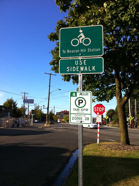
Signs mark directions on the Neighborhood Greenway at 18th Ave. S. and S. Forest St. Photo by Dylan Ahearn.

Councilmember Bagshaw, chairing the newly formed Seattle City Council’s Parks and Neighborhoods Committee, is excited to include Neighborhood Greenways on her agenda.  “Greenways connect parks and schools, community centers and neighborhood business districts. Neighborhood Greenways help with transportation, and they help with getting people where they want to go within their own communities.” (Watch a YouTube video of Councilmember Bagshaw’s announcement here.) Councilmember Bagshaw and Councilmember Tom Rasmussen, who chairs the Seattle Transportation Committee, have taken great leadership initiative on Greenways.

In case you missed previous posts here and here: Neighborhood Greenways are slow-speed, low-traffic residential streets made even more pleasant for the people who live, walk, and bike on them. By adding new park-like amenities and limiting cut-through traffic, Greenways are naturally attractive both for families, and for anyone seeking a safer, more connected community experience. By placing Greenways a block or two away from major arterials, Neighborhood Greenways create a great option for people who prefer to walk or bike away from congested streets. While many new dedicated walking and bicycling trails are beyond the reach of our City’s budget, 10 miles of Greenways can be built for the cost of a single mile of new trail, offering the potential to bring a high-quality network to all Seattle neighborhoods at a comparatively low cost. Neighborhood access by emergency service vehicles and freight delivery vehicles—and parking—is preserved along Greenways.

If you would like to get involved with Greenway planning on Beacon Hill during these exciting times please visit the Beacon BIKES webpage and come to our February meeting!

Neighborhood greenway organizers meeting on Beacon Hill next Tuesday

This sign was placed on the 17th Avenue South greenway on North Beacon Hill. Photo by Wendi.

A Seattle city-wide neighborhood greenway organizers event will be held on Beacon Hill at the Beacon Hill Library next Tuesday, January 10, from 6-7:45 p.m. Beacon Hill currently has a new greenway in progress along 17th/18th Avenues South, between Jefferson Park and the Mountains-to-Sound Trail. For more information on what neighborhood greenways are all about, see this video about Portland’s greenways project.

Here’s the announcement for next Tuesday’s meeting:

Seattle’s Neighborhood Greenways movement is attracting many newcomers to bike advocacy who are eager to transform Seattle into a city where everyone can bike and walk safely. Come join us to learn about the history of bike advocacy in Seattle, and how our growing Neighborhood Greenways movement can complement the hard work that’s already been done to make Seattle one of the nation’s most respected cities for bicycling and walking.

We are privileged to welcome Blake Trask as our featured speaker for this meetup. Blake is the chair of the Seattle Bike Advisory Board (SBAB) and is the Statewide Policy Director of the Bicycle Alliance of Washington (BAW). He’ll be providing us with the context for Seattle’s current (2007) Bicycle Master Plan: who was involved in it? What was the vision? What were the biggest challenges? And how can Neighborhood Greenways be incorporated into the 2012 update to the Bicycle Master Plan?

Blake brings a wealth of knowledge and many years of experience in improving bike safety “from the inside”. By learning from Blake where we’ve already been as an advocacy movement, we will be even better equipped as Neighborhood Greenways organizers to “work within the system” to make bicycling and walking safe and attractive for all Seattle.

We will also be discussing the upcoming neighborhood project fund grants (deadline Feb 1). This is a great and easy way to get some Greenways built in your neighborhood NEXT YEAR!

Please attend this meeting if you can.

Greenway signs sprout on 17th and 18th Avenues

New wayfinding sign on the 17th/18th Avenue South Greenway, on 17th Avenue just south of South Forest Street. Photo by Wendi.
New signs appeared along 17th and 18th Avenues South recently, the first visible step toward the new Beacon Hill Greenway, part of a planned network of neighborhood greenways on Beacon Hill. The signs direct cyclists to neighborhood locations such as Jefferson Park and Beacon Hill Station via the greenway route.

Greenways are residential streets that are designed to be safe neighborhood connections for bicyclists and pedestrians, while still allowing automobile access using traffic calming measures. (City Councilmember Sally Bagshaw has posted a FAQ with more information about neighborhood greenways on her website.)

Seattle’s greenways have recently seen a lot of press, including articles in The Seattle Times, Publicola, Seattle Bike Blog, and The Atlantic Cities.

For more information on bicycle and pedestrian strategies on Beacon Hill, see the Beacon Hill Family Bicycle and Pedestrian Circulation Plan, a ten-year plan put together by Beacon B.I.K.E.S. and ALTA Planning + Design. (See also the appendix.)

Beacon B.I.K.E.S. meeting tonight

BEACON B.I.K.E.S. (Better Infrastructure Keeping Everyone Safe) will be meeting tonight, September 6, from 6-8 p.m. in the Beacon Hill Library conference room. Light refreshments will be provided. The meeting is open to all who are interested in safely getting people of all ages and abilities around the Hill on foot and bicycle.

Tonight’s agenda includes:

  • Debrief of previous month’s events
  • Discussion of Seattle Greenways potluck on September 14
  • Event logistics for 350.org Moving Planet on September 24
  • Crossing counts at Spokane and Lafayette
  • NEPO 5k Don’t Run: volunteers for Serpent Walk
  • Hilltop Red Apple bicycle parking update
  • Other announcements

See more about Beacon B.I.K.E.S. at http://www.beaconwalksbikes.org/.

Biking on Beacon: Why did the neighbor cross the road?

…To get to our brand new park!

Jefferson Park is a wonderful community gathering space located in the heart of Beacon Hill.  It offers amazing views, brand new tennis courts, playground, cricket, lawn bowling, golfing, a community center, and soon we will have a skate park and spray pad (which would not have gotten much use this summer, somewhat diminishing the sting of construction delays).  But the irony is this community nexus acts as a physical division within our neighborhood. The golf course is not permeable by car or foot, while the park is surrounded by arterial and collector streets (Spokane, Columbian, Beacon) that are wide and unsafe to cross except at stoplight-controlled intersections.  Due to the current configuration it is difficult to access the park in a safe and efficient manner without getting in your car and driving there, which I must say, though I love my car, does take the neighborhoodiness out of things a bit—when was the last time you had a meaningful interaction with a neighbor when driving past them on 15th?

Neighbors have noticed that many people try to access the park by foot by crossing Spokane between Beacon and 15th Ave. S. (at 16th, 17th, Lafayette, and Alamo).  Though legal, crossing Spokane at these intersections across 4 lanes of fast-moving traffic with no marked crosswalks and difficult sightlines is not the most relaxing stroll to the park.  A solution proposed in Beacon Hill’s Bike and Pedestrian Circulation Plan is to create a safe pedestrian crossing at Lafayette Ave. S.  The first step to adding a new pedestrian crossing is data collection.  Within the past month folks from Beacon B.I.K.E.S. have conducted pedestrian crossing counts and even shot a nice video at the proposed crossing.

The results from the counts indicate that during peak hours around 20 people per hour will cross Spokane at these dangerous intersections.  This is considered a high enough rate by SDOT to justify a pedestrian crossing.  SDOT will soon be conducting their own counts and studies and hopefully we will get the crossing installed next year!  Of couhttp://youtu.be/dvqw7D8-6aYrse, it won’t happen without a lot of community support, so if you are interested please contactBeacon B.I.K.E.S. and send an email to Peter Hahn (SDOT director) letting him know this is something the neighborhood needs.

See you at the Park!

People-Powered Park Parade a success

Judith Edwards of the North Beacon Hill Council and City Council member Sally Bagshaw have a discussion at last Saturday's People-Powered Park Parade. Photo by Dan Bennett in the Beacon Hill Blog photo pool.
I was very sad to have to miss last weekend’s People-Powered Park Parade in which neighbors on bicycle and foot toured the proposed bike boulevard on 17th and 18th Avenues S., and celebrated the 100th birthday of Lewis Park. Though the weather wasn’t perfect, the rain stayed away, and those who were able to attend report that it was a lovely celebration.

A neighbor going by “Observer” posted this recap in the comments to last week’s post:

It was a two-fold community celebration. The Friends of Lewis Park and Beacon Bikes joined forces with the City of Seattle, Department of Neighborhoods, North Beacon Hill Council and Green Seattle Partnership in sponsoring the People Powered Park Parade and celebration of four years of restoration of Lewis Park Natural Area.

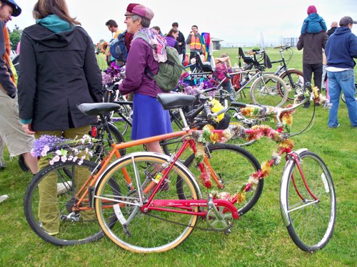
The colorful bike parade was in celebration of the vision of a kid-friendly bicycle and pedestrian path connecting our Seattle Parks with safe and enjoyable neighborhood greenways. An estimated (I didn’t count) 50 or more bicyclists of all ages departed the Jefferson Park playground and rode the proposed path to Lewis Park to the north.

Upon arrival the riders and walkers (who seemed to double in numbers) were greeted by the Friends of Lewis Park and several dignitaries from the City of Seattle. Two of the more popular neighbors were Jay Hollingsworth and J.J. Lund. People lined up and down the block to meet them as they flipped the burgers and dogs and stirred the chili.

Director Dee Dunbar introduced several dignitaries that included Seattle Mayor Mike McGinn. Each of them shared a similar message of congratulations to the citizen volunteers who are providing the many hours of hands on labor to achieve the goal of restoring the Lewis Park Natural Area to a beautiful, family-friendly environment. They expressed great appreciation to citizens of the neighborhood who are making it happen. They also recognized the grants awarded to the project were really quite small when compared to the investment of time and work of the citizens of north Beacon Hill.

This is certainly not an official report but rather an observation from a long time citizen of north Beacon Hill.

Kat Marriner posted her take on the day’s events, with photos, on the Yellow Tent Adventures website. City Council member Sally Bagshaw also blogged about the event.

Dan Bennett posted a wonderful bunch of parade photos to the Beacon Hill Blog photo pool on Flickr, and Observer emailed us some great photos as well. (Thank you to both of you!) Here are a few of our favorites:

City Council member Sally Bagshaw and others on the People-Powered Float. Photo by Dan Bennett.
Photo by Observer.
Mayor McGinn meets Beacon Hill neighbors. Photo by Dan Bennett.
Bikes brightly decorated. Photo by Observer.
Cyclists wait to cross Spokane Street. Photo by Dan Bennett.

People-Powered Park Parade and Lewis Park Celebration this Saturday

As mentioned previously, the People-Powered Park Parade and Lewis Park Celebration is this Saturday, May 21. The PPPP is a bike and walk parade that will tour the proposed bike boulevard on 17th and 18th Avenues S., and celebrate the 100th birthday of Lewis Park. You can see the parade route here.

Here is the event timeline; come for the entire event, or just part of it, if you prefer.

At Jefferson Park Playground, 3801 Beacon Ave. S.:

  • 11:30 a.m. Gather and decorate bikes
  • 11:40 a.m. Lion dancers
  • 11:45 a.m. Introduction, CM Rasmussen speaks, parade instructions
  • 12:00 p.m. Leave Jefferson Park and travel the proposed Beacon Hill Bike Boulevard/Greenway

At Sturgus Park, 904 Sturgus Ave. S.:

  • 1:00 p.m. Event begins (BBQ, music, arrival of bike parade)*
  • 1:25 p.m. Mayor arrives, mix and mingle
  • 1:30 p.m. Welcome by Friends of Lewis Park
  • 1:35 p.m. Duwamish blessing
  • 1:45 p.m. CM Sally Bagshaw (3-5 min)
  • 1:50 p.m. Mayor’s remarks (3-5 minutes)
  • 1:55 p.m. Christopher Williams (3-5 minutes)
  • 2:00 p.m. Bernie Matsuno (3-5 minutes)
  • 2:15 p.m. Tours of Lewis Park Natural Area begin, music resumes
  • 5:00 p.m. Event concludes

*Due to limited seating, it is advised that you bring a blanket/something to sit on to Sturgus Park.

This event is organized by Beacon Walks and Bikes and Friends of Lewis Park, and funded in part by a Neighborhood Matching Fund award from the Seattle Department of Neighborhoods. For more information, contact Dee Dunbar at dd1377@gmail.com or Dylan Ahearn at dsahearn@gmail.com.