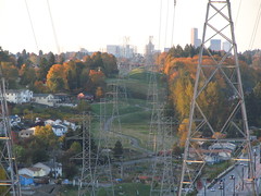
From the right angle, these power lines prevent a clear view of the towering office buildings downtown. Photo by WendiSeverallocalmediaoutlets have picked up a story of some neighbors on the far-west edge of the hill whose views have become scarred due to taller power poles with thicker power lines, purportedly installed by Seattle City Light at the behest of Sound Transit to accommodate the power requirements of the light rail station.
Beacon Hill neighbor Roger Pence, who works with Sound Transit, said on the mailing list:
…these power lines have nothing to do with Sound Transit. We didn’t know they were going up either! This is a “betterment” project entirely the doing of Seattle City Light.
Later reports indicate that City Light upgraded the service to power trolley buses and in expectation of increased demand in Rainier Valley.
(Tangentially, I noticed the trucks on Stevens between 12th and 13th yesterday morning, and when I called City Light to inquire about them , I was told it they were performing sewer work. “TV sewer inspection.” Odd. Updating with links as they appear.)
Now we come to some interesting questions. How do we approve or “validate†our North Beacon Hill neighborhood plan recommendations before they are submitted to the City Council in November/December? Of course no one has any idea what exactly will be proposed by Department of Planning and Land Use (DPD) in September. But whatever comes out of the amazing brainstorming that has been going on, be it rerouting car traffic off Beacon Avenue onto 15th to create a bus, bike, pedestrian campus, or increasing zoning heights to 65′, or creating public benefit “baskets” for the key development properties (El Centro, Red Apple, Sound Transit block), or starting a temporary community garden on the empty land around the station, the ideas are all big, bold and exciting.
As a community with a number of different interest groups. we have to vote, or something, to say neah or yeah. And, we have to hope that DPD can correctly interpret our input in the short time between September and November 20 when the proposal must be submitted to Council (unless they give us more time). Who should get to vote, approve or validate our plan? I assume it will be residents and business owners of North Beacon Hill. How will DPD figure out who is validating? Will it just be community or will they inadvertently or intentionally also include developers, or people who don’t live here? Another question that has arisen for me is: how do the small business owners on Beacon Avenue get a fair say? Continue reading Commentary: Stewardship, validation and small business owners→
(As the big opening day for light rail is this Saturday, we want to post a bit about the stations that aren’t on Beacon Hill. Much of the coverage of the rail line focuses on using it for commuting to and from work, and many of us will be doing that. But even more than getting to work, Link is going to be useful for visiting places throughout Downtown and Southeast Seattle without a car. With this in mind, we’ve created a few posts about some of the station areas.)
The pictogram representing the Columbia City station is a dove. (Courtesy of Sound Transit.)
The Columbia City Station is located on Martin Luther King Jr. Way South, just on the western edge of Columbia City. The station site itself is just south of a new development, Rainier Vista, a former public housing site originally built in the 1940s to house defense workers, and recently redeveloped as a multi-income community inspired by New Urbanist principles.
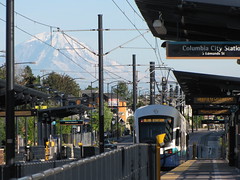
Walk from the south end of the station east on South Edmunds Street, and after about one-third of a mile you’ll emerge on the neighborhood’s main drag, Rainier Avenue South, just south of Southeast Seattle’s only full-time movie theater, the triple-screen Columbia City Cinema. Further north on Rainier is the recently-expanded Columbia Branch Library, a Georgian Revival-style Carnegie Library building from 1915. The library is listed on the National Register of Historic Places. A train leaves the Columbia City station while Mount Rainier dazzles in the background. Photo by Wendi.The wider Columbia City business district is itself a Seattle Landmark District (one of seven historic districts in the city) as well as a National Register Historic District, and includes a variety of interesting commercial buildings, houses, churches, and apartment buildings. The Seattle.gov website has a Historic Tour of Columbia City that you can print out and follow as you explore the neighborhood.
Restaurants in Columbia City are plentiful and you can choose from cuisines including Caribbean, barbecue, Neapolitan Italian, Ethiopian, Vietnamese, and more. There is also a brewpub, the Columbia City Ale House. (CC Ale House doesn’t actually brew, but they do have a fairly large selection of local and regional microbrews — Ed.)
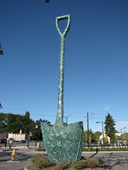
The Global Garden Shovel sculpture is impossible to miss, on the northwest side of the station. Photo by Wendi.If you feel the need to eat before walking to the heart of Columbia City, much nearer the station is the Japanese fast-food restaurant Maki & Yaki, serving teriyaki, sushi, bento boxes, and more just north of the MLK and South Alaska intersection.
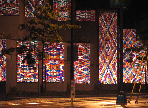
Like the other light rail stations, Columbia City Station is surrounded by public art, including Victoria Fuller’s Global Garden Shovel, a giant bronze shovel molded with the shapes of fruit and vegetables. In Norie Sato’s Pride, the south plaza of the station is guarded by lions customized to reflect the diversity of the neighborhood. When you are riding the train north from Othello Station to Columbia City, look to your left between Dawson Street and Hudson Street to see Sound of Light, by artist Richard C. Elliott, made of hundreds — perhaps thousands — of reflectors arranged in overlapping, symmetrical patterns. (See this one in both day and night, if you can.)
Sound of Light, by the late Richard Elliott, as seen at night, lit up by the lights of passing cars. You can only see this artwork while traveling north on MLK. Photo by Wendi.
Every so often, we drive along MLK to observe light rail construction progress. It’s been really fun lately to see trains running. We went out to Kubota Gardens a few weeks ago and stopped off at Thai Palms on the way home.
Thai Palms is located on a busy stretch of MLK, near the Othello light rail station and not far from Holly Park Greenhouse & Nursery.
The restaurant is clean and comfortable, decorated with wicker and bright flowers. Our server met us immediately at the door and was attentive and polite. He brought two delicious iced coffees immediately. My dining companion was disappointed to hear there was no beer–Thai Palms doesn’t have a liquor license yet.
We were impressed by the extensive menu–at least four pages listing everything from Thai standards (phad Thai, Lard Na, Tom Yum) to items I didn’t recognize and can’t remember how to spell. If you have a favorite Thai dish, they probably make it here.
We started with fried egg rolls. They were fine–nothing special, but hot and brought out quickly. Next time, I’ll definitely go for the fresh rolls and/or the salt & pepper tofu as a starter.
I ordered a Massaman curry and jasmine rice. The curry was rich with coconut milk and spiced just right. 3/5 stars was perfect here–warm enough to make my nose tingle, but not so hot I cried. Shane enjoyed his Phad Thai, which contained traces of tamarind and shrimp paste and lacked the ketchup-induced sweetness and pink hue so often found in that dish.
Service lagged between our egg rolls & the main dishes. I couldn’t tell if it was simply because the main dishes were being fresh made, or because there was a shift change. We would have appreciated drink refills and some idea of when our food was coming out.
Overall, I recommend Thai Palms. It was tasty, inexpensive (less than $30 for two entrees, coffee, and an appetizer), and nearby. Once the trains start carrying passengers, we’ll venture down again.
Neighborhood: Rainier Valley
6715 Martin Luther King Jr Way S
(between Holly St & Willow St)
Seattle, WA 98118
(206) 721-7777 thai-palms.com
(As the big opening day for light rail is this Saturday, we want to post a bit about the stations that aren’t on Beacon Hill. Much of the coverage of the rail line focuses on using it for commuting to and from work, and many of us will be doing that. But even more than getting to work, Link is going to be useful for visiting places throughout Downtown and Southeast Seattle without a car. With this in mind, we’ve created a few posts about some of the station areas.)
The pictogram representing the Othello station is a stag. (Courtesy of Sound Transit.)The Othello Station is located in a neighborhood on the verge of great change. Though the area currently has a few empty lots and what the Seattle Times recently called “a weary row of shops,” the station is already spurring new transit-oriented development in the area: a 420,000 square foot mixed-use project is breaking ground right next to the new light rail station. The New Holly redevelopment of the former Holly Park public housing project is just up the hill, and the similar Othello Station planned community is next door. The station area bears the weight of heavy expectations, perhaps more than any of the other station locations.
A Link train arriving at Othello Station, last fall. Photo by Oran Viriyincy.Attractions and destinations nearby include the Chief Sealth Trail, which also comes close to the Rainier Beach Station, Othello Playground, the New Holly library, and the BumblebeeBoxing Club. And while certainly nothing to write home about, this stop brings the nearest Safeway to any of the stations although it’s also quite possibly not going to be a Safeway for terribly much longer. The Rainier Valley Post reports today that the store has a $3 million makeover coming in January.
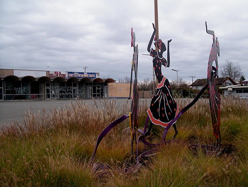
The public art around the station includes Roger Shimomura’s Rainier Valley Haiku, an exploration of Asian identity and culture in 21st Century America; Brian Goldbloom’s Stormwater Project, granite catchbasins inspired by Japanese stonework; and Augusta Asberry’s Come Dance With Me, in which eight stylized women dance along the edge of MLK in colorful dress.
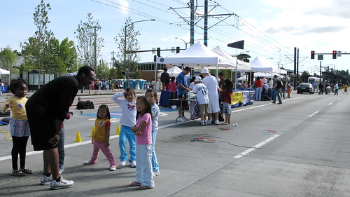
Othello neighbors enjoyed the MLK Safety Street Fair last year, but this Saturday's celebration promises to be even more festive. Photo by Oran Viriyincy.“Downtown” Othello has a fair number of restaurants to choose from, mostly ethnic food, including the much-loved Tacos El Asadero bus on MLK between South Othello Street and Renton Avenue South. Olympic Express has lamb curry, gyros, and halal meats, along with Asian fast food such as pho and teriyaki. Rose Petals serves up southern food: greens, ox tails, cornbread, and fried chicken, “like fife and drum music for my stomach,” according to one Yelp reviewer.
The Othello Station area will be particularly festive on Link’s opening day, July 18, when a free community festival to celebrate light rail’s arrival will be held at MLK and South Othello Street. There will be food, art, commemorative souvenirs, “Undriver’s Licenses” for everyone, and entertainment including Massive Monkees, the Lion dancers, Big World Breaks, Ruby Shuz, and more.
The "Come Dance With Me" women by Augusta Asberry danced in front of a forlorn retail building last winter, since torn down to be replaced by a mixed-use development. Photo by Matthew Rutledge.
Updated with new information about the Othello Safeway remodel.
(As the big opening day for light rail is this Saturday, we want to post a bit about the stations that aren’t on Beacon Hill. Much of the coverage of the rail line focuses on using it for commuting to and from work, and many of us will be doing that. But even more than getting to work, Link is going to be useful for visiting places throughout Downtown and Southeast Seattle without a car. With this in mind, we’ve created a few posts about some of the station areas.)
The pictogram representing the Rainier Beach station is a heron. (Courtesy of Sound Transit.)The Rainier Beach Station location has an oddly rural appearance, due to its location near the Chief Sealth Trail and the large Thistle Street P-Patch. There is not yet any kind of high density development in this area, and the City Light power lines that rise over the trail and p-patch will prevent those areas from being developed in the future. This area was rural well-within living memory, and in fact, Seattle’s last working farm, Sferra Farm, is fairly close by.
Several blocks to the east is Rainier Avenue and Rainier Beach High School. Another few blocks get you to Beer Sheva Park on the shore of Lake Washington. Just over a mile’s walk south on the Chief Sealth Trail from the station will get you to the famous and lovelyKubota Garden.
The Chief Sealth Trail undulates down Beacon Hill to the Rainier Beach Link station. Photo by Wendi.Beaconians, still without any pizza restaurants on the hill (unless you count the Domino’s on the very lowest part of the hill on McClellan, but we don’t), might find the Link train to be their pizza express, since the Rainier Beach station is only one long block away from Vince’s, where they’ve been serving pizza and gnocchi and spaghetti for 52 years now. Dinner at Vince’s is like stepping back in time; dark, with Sinatra on the sound system and checkered cloths on the table, it’s a classic old-style Neapolitan-American restaurant, probably not much different from the way it was in 1957. Comfort food doesn’t get much more comfortable than this. (There’s a bar, too.) If Italian food isn’t your thing, there is a taco wagon about half a mile north of the station on MLK.
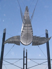
"Dragonfly" above the Rainier Beach Station. Photo by Wendi.The station itself, like most of the other Rainier Valley stations, is a platform station. Metal panels by artist Eugene Parnell are embossed with hieroglyphics and other forms of writing and stand throughout the platform. An aluminum creature, “Dragonfly” by Darlene Nguyen-Ely, soars over the north entrance. Nearby is Buster Simpson’s “Parable,” meant to be pear halves that reflect the farming past of the Valley, with cables and rails to symbolize the encroachment by urban Seattle that changed the neighborhood. This, however, is one of the less-successful artworks at the stations, as at a glance, it just looks like a pile of rusty junk left over from the station’s construction. A better evocation of old farming Seattle is just across MLK, where the P-patch farmers continue an old South Seattle tradition.
Artwork by Eugene Parnell on the station platform. Photo by Wendi.
(As the big opening day for light rail is this Saturday, we want to post a bit about the stations that aren’t on Beacon Hill. Much of the coverage of the rail line focuses on using it for commuting to and from work, and many of us will be doing that. But even more than getting to work, Link is going to be useful for visiting places throughout Downtown and Southeast Seattle without a car. With this in mind, we’ve created a few posts about some of the station areas.)
On Link maps and printed materials, each station has a symbol. Tukwila Station's symbol is a canoe, to refer to its history on three rivers and future as a transportation hub. (Courtesy of Sound Transit.)Of all the stations on the Link light rail line, Tukwila International Boulevard Station is the most frustrating, at least, from the perspective of anyone who doesn’t live or work in the area. Of all the stations, it has the fewest neighborhood attractions to visit. What it does have that none of the other stations do is one thing: a 600-space park and ride.
Even Sound Transit’s own promotional materials struggle to find nearby attractions for this station. The Discover Link Neighborhoods Interactive Map gives as this station’s nearby attractions Southcenter Mall (about 1.75 miles away), the Interurban Railroad (historically interesting, but there really isn’t anything left of it to see), and the Museum of Flight, a whopping five miles away on East Marginal Way. (If you really want to see the Museum, and you’re willing to hoof it a bit, don’t take the train to Tukwila — get off at Rainier Beach and walk two and a half miles to the Museum, which is less than a mile away as the crow files, but is on the other side of I-5.) Other “points of interest” mentioned elsewhere by Sound Transit include Fort Dent Park (a couple of miles away) and Boeing Access Road (several miles away near the Museum of Flight, and not an “attraction” per se). In other words, there’s not much there there, near the station itself. We could all use a little more walking, but if you are willing to take the train to Tukwila only to walk 5 miles to get to the Museum of Flight, you’re a more intrepid walker than I.
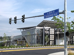
The Tukwila station as seen from International Boulevard. Photo by Wendi.What there is to see at this particular station is the station itself. Larger than most of the other stations, its design is big, glassy and modern. The roof soars above the station at an angle for takeoff, and the tracks elevated high in the sky make you think of a monorail instead of an earth-bound light rail.
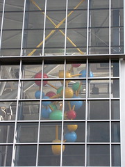
Like the other Sound Transit stations, Tukwila has its share of art, including a giant milk drop caught in mid-splash, A Drop of Sustenance, and a huge brightly-colored molecule, Molecule of Tukwila, both by Tad Savinar. Outside the station grounds, though, there is not much art, but instead a suburban auto-oriented highway-strip neighborhood of the type that grows up around all old highways (in this case, it was formerly part of US 99, then SR 99): a gas station, McDonalds, KFC, a former casino, a Pancake Chef, bars and strip clubs populate the strip. There are nearby halal grocery shops, and a post office that stays open until late at night to accept your packages. Until the SeaTac Airport station opens in December, there will also be a shuttle bus waiting here to get you to the airport.
Molecule of Tukwila, as seen from outside the station. Photo by Wendi.Ben Schiendelman commented recently on one of my photos of this station that “It’s a terrible place for a station this year, but not in 20 years. And it’ll be around for 150…” With luck we won’t need to wait that long for a reason to visit.
Captain Liggins has commanded the South Precinct since 2008. Photo from seattle.govAt last week’s NBHC meeting, South Precinct Captain Les Liggins came by and talked a bit about burglaries in the neighborhood. He said that it has been “one of the most interesting last couple of months I’ve seen in my career,” a period of time that “started off with, I felt, a significant burglary increase in the precinct.” He cited one primary reason: “As we enter the summer months when schools are out… kids are getting out and looking for things to do… like raid a few houses.”
“Thanks to timely phone calls, we’ve been able to make significant headway,” performing an arrest during a burglary in progress, and then getting them to roll over on their associates, leading to the recovery of 300 laptop computers and other electronics.
He also said that the police have been “fortunate lately… to get significant hits on fingerprint evidence… placing people inside the houses…” and “also fortunate… our numbers are increasing… almost at 100 (officers, up from 70)”. They are trying to get their staffing up throughout the department to match workload and “get most officers out on the days and times when most activity occurs.”
Unfortunately, the impact of that well-timed arrest, the leads coming from it, and the accumulation of fingerprint evidence has not fully quelled the rash of break-ins and burglaries nearby.
Kevin on the mailing list wrote about a break-in yesterday, 7/13, at his home near 21st & McClellan. Alma responded with a note about the theft of garden tools and such the same day, 7/13, from her neighbor’s new shed near 15th & Nevada. Suzanne wrote to us about her home being burglarized last Wednesday, 7/8, at 18th & Bayview.
Keep your eyes open and don’t hesitate to call 911 if you see something suspicious.
Update: a number of additional burglary calls today on the scanner, reported by BHNW: 18th & Lucile, 3700 block of Holly Park Drive, 5100 block of 20th Ave S, and the “6500 block” of 19th Ave S (I suspect that’s a typo).
Update:Corrected some dates. It’s not Wednesday yet.
Jefferson Park reservoir work, 2007. It won't be going back quite to this stage, presumably. Photo by Jason
West Seattle Blog just broke a story about problems with leaky “membranes” applied to both the Beacon Hill Reservoir at Jefferson Park and West Seattle’s Myrtle Reservoir projects.
Repairing the problem will require removal of grass, dirt and “drain rock” lids covering the nearly-completed reservoirs to get to the membrane material. After replacing the faulty waterproofing, it will be re-covered. Who pays for the repair work will likely be resolved in court, and how far out this pushes “completion” of the project is unknown.
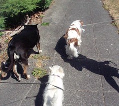
Dogs on the Hill reflect a neighborhood of diversity. Photo by melissajonas.My 8 year old niece was recently visiting from Eastern Washington. One of her favorite things about coming to see us is being able to walk the neighborhood dogs. There’s a 9 year old who visits her grandmother next door, and the girls have become close “vacation friends”. We allow them to take the small dogs around the block alone—reminded each time about safety and sticking together.
On our block alone, we have a West Highland Terrier, a Belgian Malinois, a Shih Tzu, a black Lab, a Whippet, a King Charles Cavalier Spaniel, and our mixed breed Tica. If you cross a street in any direction, you’ll meet an English Bulldog, a Catahuoula, a Min-Pin, more Labs… an incredible variety of dogs. My niece is fascinated by the diversity, and loves learning the names of breeds and their history.
I share her love of doggy diversity, and have fun watching the big dogs play with the puppies—and how well all the dogs behave around the little girls.
Beacon Hill is also an incredible example of human diversity. Staying within one block of our house, you will smell cooking from every continent and hear over a dozen languages being spoken over the dinner table. We have new babies and great grandparents, a wide range of income and education levels, different sexual orientations, and families of every possible composition.
Walking the dogs has given me—and now my niece—a chance to develop an appreciation for the similarities our neighbors share. Everyone smiles when they see two little girls holding leashes or selling lemonade. Everyone strives to create a safe, welcoming place.
Our neighborhood is a community. New neighbors are welcomed by those who have lived here 50 years. History, current events, and hopes and fears for the future are all discussed in front yards and on street corners. I celebrate our diversity, and I cherish every chance we have to come together.
Beacon Hill has seen many changes over the generations, and we will see more as light rail begins. We’ve weathered several years of construction and traffic challenges, and I expect some bumpy patches as we face increased numbers of people coming through (and moving to) the neighborhood. I’m confident that this diverse, welcoming community will continue to come together to face every challenge and celebrate every positive change.