We haven’t seen our cat in a few days, and we think she may have lost her way home or be stuck in someone’s home/garage/basement/front window, as she tends to be a fearless wanderer and the weather was bad over the weekend. I saw her last on Thursday, the 10th of November. We live on 14th between Dakota and Nevada. Her name is Rishi (Ree-Shee), she is a small Oriental Tabby. She is not wearing a collar, but is micro-chipped. Her family, especially our two year old, is ready for her to come home. Please call us at 206-972-0045 (Kt) or 206-650-5874 (Bo) if you have seen her or have her.
Knives like this work best when kept sharp. Photo by bradleypjohnson via Creative Commons.Lynn Tucker on the Beacon Hill community mailing list organized a visit to the Hill from the mobile knife sharpening service, Cutlery on Wheels. Owner Bill Magee can sharpen knives, kitchen tools, fabric scissors, hair scissors, and more. The cutlery truck also contains a “Showroom on Wheels” with knives and culinary tools for sale.
Cutlery on Wheels will be parked in front of The Station coffee shop at 2533 16th Ave. S. on Saturday, November 19 from 10 a.m. until about 4 p.m.
Lynn adds:
“It usually takes about 30-45 minutes to do 6-8 knives and kitchen or sewing scissors depending on how many people stop in to drop off more knives. Prices depend on length of blade. I paid about $38 for 8 knives of varying lengths. Bill will do hand garden tools at the end of the day as he needs to change belts. He will not be able to do lawnmower blades of any kind.”
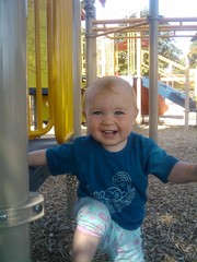
This happy child plays at the Santos Rodriguez Memorial Park. Photo by Melissa Jonas in the Beacon Hill Blog photo pool in Flickr.After extensive improvements to equipment and the addition of a covered picnic area, El Centro de la Raza opened the Santos Rodriguez Memorial Park playground to the public last summer. It’s been a hit with community members of all ages.
But wait, there’s more! Through the Parks and Green Spaces Opportunity Fund, the Seattle Parks and Recreation Department awarded El Centro an additional $350,000 to improve the park further.
To learn more and be part of the design process for the upcoming park improvements, attend the first public meeting about this project on November 15 from 6:30-8:30 p.m. at El Centro de la Raza’s Salvador Allende room, Room 106. El Centro’s address is 2524 16th Ave. S. Find out more about the project at the project’s website, or read the meeting flyer.
New wayfinding signage like this is found on the new Beacon Hill Greenway. Photo by kashgroves in the Beacon Hill Blog photo pool on Flickr.We at Beacon B.I.K.E.S. (Better Infrastructure Keeping Everyone Safe) love us some Neighborhood Greenways.
What are Neighborhood Greenways, you may ask?
Neighborhood Greenways are quiet residential streets that are optimized for pedestrian and bicycle travel. The idea is to have routes that connect our neighborhood to itself along streets that are safe for those 8 to 80 years old. The bike lanes on the arterials are only going to be used by a small minority of the neighborhood; Neighborhood Greenways, on the other hand, can be conformably used by anyone!
What does a Neighborhood Greenway look like?
The best introduction to Neighborhood Greenways is this video from Portland. Basically, a residential street that connects neighborhood destinations is outfitted with wayfinding signs, paint markings on the street (like the “sharrows” on 15th), some traffic calming (speed bumps, traffic circles), improved crossing treatments at intersections with arterials, and maybe some trees to spruce the place up.  The result is a street that gives that small town feel in the middle of the big city. Traffic is calmed where people want it calmed (in front of their homes!), bikers are off the arterials where conflicts with traffic are good for no one, use of the public space provides more eyes on the street and thus reduces the likelihood of crime, and you can bike to the park or to school with your kid without worrying for their lives.
The Beacon Hill Family Bicycle and Pedestrian Circulation Plan is basically a big network of Neighborhood Greenways on Beacon Hill.  The first Greenway route (18th Ave South/17th/Lafayette) is currently being implemented.  The wayfinding signs are up (you may have seen them around the library), the paint will be going in within a month, and as of yesterday SDOT planted about 70 trees along the route. I snapped some photos this morning of our new friends on the hill. Its not a Greenway without the Green, so we are excited that the city agreed to help us out with the trees!  Neighbors along the route with a spot for a potential tree in their planting strip were offered a choice of a couple different species of trees or no tree at all.  SDOT planted and will water the trees for 3 years until they are established.  SDOT will also prune for the life of the trees.  The trees planted were paperbark maples, Persian ironwood, “Royal Raindrops” crabapples, “Native Flame” American hornbeam, and “Emerald Sunshine” elm.
If you get the chance, take a stroll down 18th and see how our first Greenway is coming together!
Next Beacon B.I.K.E.S. meeting is Wednesday November 16th, 6-8pm at the library. Â All are welcome!
Next Tuesday, November 15, everyone is invited to “ride along” with Seattle Police officer Nate Shopay to get a taste of life for a patrol officer on Beacon Hill. That’s right, everyone. There’s room for the whole neighborhood, since it’s a virtual ride along — a Tweetalong! Shopay will use Twitter to post his experiences on a typical day patrolling Beacon Hill between South Orcas Street and South Othello Street, during the second watch shift from 10 a.m. to 5 p.m.
Shore Pine. Photo by Art Poskanzer via Creative Commons.The Trees for Neighborhoods program has extended the application deadline for Seattle residents to receive free trees to plant in their yards. Apply online here. The remaining available species, all conifers, include deodar cedar, Western red cedar, weeping Alaska cedar, and shore pine.
Trees can be picked up this Saturday, November 12, at Rainier Beach Urban Farm and Wetlands, 5513 S. Cloverdale Street .
If conifers aren’t the trees of your dreams, or if you want to plant street trees, you’ll need to wait until next fall when applications will re-open for other tree species and for street tree permits.
Microsoft has a vision of the future that includes slick touchscreens, virtual buskers, transparent refrigerator doors, and a Hong Kong subway station that looks oddly familiar. (The station can be seen starting at 1:19 in the video.)
Two new liquor licenses have been granted to Beacon Hill businesses.
El Quetzal, at 3209 Beacon Ave. S., received a license of the type “Spirits/beer/wine restaurant service bar; off-premises sale of wine.†This was an additional liquor license class beyond their previous license, and allows the restaurant to sell wine by the unopened bottle for off-premises consumption.
Amazing views greet cyclists on the Mountains-to-Sound Trail. Photo by Willie Weir.by Willie Weir
(This article is cross-posted, with permission, from the blog Yellow Tent Adventures. — Ed.)
Recently ribbons were cut and speeches were made at the opening of the new segment of the Mountains-to-Sound Trail. Any additional trail miles that provide needed access for bikes and pedestrians is cause for celebration. Except that the Mountains-to-Sound Trail now officially ends at a blind corner of a very steep hill.
Holgate, which rises to and descends from Beacon Hill, is legendary on this side of the city. It is the type of road that even some seasoned cyclists choose to avoid. If you are descending it from the top of Beacon Hill, you can easily hit 40mph without a single pedal stroke. You just take the lane and fly. The road crosses I-5, and at this point as a cyclist, you need to be hyper-aware as you dump out onto the left lane of traffic. Cars turning from Airport Way S. are speeding to make the light at 6th Ave. S. Many motorists like to make a left hand turn across your path as they exit the Office Depot. And the road surface is a photo op for the “repave our streets†campaign.
On the way up Holgate you are in a narrow lane with a high curb on your right as you climb over I-5. The thought that a car clipping you could send you catapulting onto the freeway is enough to have many cyclists choose to ride on the left hand sidewalk and then cross over at the blind corner as the sidewalk ends. Sounds fun, doesn’t it?
Can you imagine parents riding their bikes along with their two young kids tackling any or all of this? It sounds rather nightmarish.
And yet it is a possibility. The Mountains-to-Sound Trail is a separated recreational path. The type of trail that is desirable for riders and walkers who aren’t comfortable in traffic. The recently opened extension expands the trail from 12th Ave. S. to Holgate. The path is a delight and offers beautiful vistas of downtown Seattle. I had a hard time wiping the grin off my face the first time I rode it.
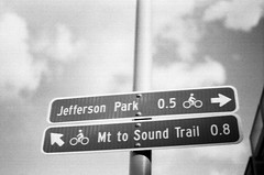
The end of the Mountains to Sound Trail at the blind corner of Holgate and Beacon Ave. S. Photo by Willie Weir.My grin faded at Holgate. The sign simply reads, “End. Mt. to Sound Trail†That’s it. No more information.
What is the family with their two kids going to do? They’ll look at the option of crossing the road at the blind intersection and climbing the steep hill to their left. But what’s up there? They don’t know, because they are visiting from Spokane or Missoula and they don’t know that at the top is the business district of Beacon Hill with a light rail station, bus connections, stores, restaurants, a library, and a huge park. No, to them it’s just a big scary hill to destinations unknown.
Then they’ll look down the hill and think, “The Sound is that way.†They’ll opt to walk their bikes down the sidewalk because the hill is steep and their kids are scared. This is good. Because that sidewalk ends in a flight of stairs. To their credit, SDOT has posted a sign regarding this about 200 feet before impact.
The sidewalk down Holgate quickly becomes a stairway, dangerous for bikes. Photo by Willie Weir.Now our visiting family is stuck. Because to continue forward means having to lift their bikes onto a narrow road with speeding traffic and “take the lane, kids.†Beyond this dangerous move there is no signage letting them know that they are three blocks away from the bike path that runs parallel to light rail.
But I’m guessing at this point our family will opt to turn around and push their bikes back up the sidewalk. The kids will be crying and Mom and Dad will think, “This is unsafe and crazy.†They will finally reach the trail and backtrack from whence they came.
What the family doesn’t know is that the Mountains-to-Sound Trail will eventually be completed. There will be a switchback trail that crosses under the freeway and connects to the bike trail and light rail station at Royal Brougham. But construction of that section isn’t even scheduled yet… so it’s years away.
In the meantime, information needs to be posted that gives everyone an option. Experienced city traffic cyclists can take a right at Holgate and shoot into the Sodo District or take a cautious left and climb to the Beacon Hill business district. Others can backtrack and follow the bike route signs to downtown, or be routed that way to begin with.
The dangerous conditions at the blind curve where Holgate becomes Beacon Ave. S. need to be addressed. This is now more important than ever! This is one of the few accessible routes up to Beacon Hill and it should be made safe for everyone.
The Mountain-to-Sound Trail extension is great! It will be better when it is finished (South Seattle’s missing link?). But until then, we need signage that explains the current conditions, and improvements that give everyone safe options. Without them, the ride doesn’t end well.
It’s Election Day, and while the focus on one specific election day has dimmed somewhat since we switched to vote-by-mail, it’s still the deadline for turning in your ballot. Ballots must be postmarked today or returned to a ballot drop box by 8:00 pm to be counted. (If you get your mail to the mailbox after the final pickup of the day, you won’t get a November 8 postmark, even if the final pickup is before 8 p.m. Be careful to check pickup times.)
If you would rather not use a stamp to mail in your ballot, you can drop off your ballot at one of the county’s official ballot drop boxes. The nearest ones to Beacon Hill are located downtown, at the King County Administration Building (500 4th Ave), and in the International District at the accessible voting center at Union Station (401 S. Jackson St.). There are no drop boxes in Southeast Seattle.
If you have lost or damaged your ballot, or if you are one of the up to 21,000 voters who did not receive ballots, you can vote the old-style way in a voting booth at the accessible voting center, until 8 p.m. tonight. Bring your identification. However, the Union Station voting center is one of only three in the entire county, so be aware that there may be lines at peak periods. Get there early if you can.
The first batch of results will be posted to the King County Elections page tonight at 8:30 p.m., and thereafter at 4:30 daily. Unfortunately, the 8:30 batch is the only batch of results that gets posted on Election Night these days, making Election Night parties a bit less suspenseful.
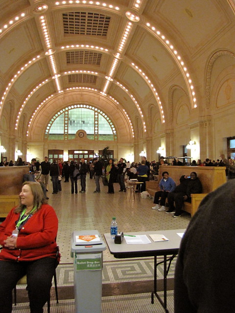
Last November, voters at the Union Station accessible voting center waited as much as three hours to vote. However, there was no wait to use the ballot drop box. Photo by Wendi.
 Neighbors Kt and Bo write:
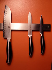


 It’s Election Day, and while the focus on one specific election day has dimmed somewhat since we switched to vote-by-mail, it’s still the deadline for turning in your ballot. Ballots must be postmarked today or returned to a ballot drop box by 8:00 pm to be counted. (If you get your mail to the mailbox after the final pickup of the day, you won’t get a November 8 postmark, even if the final pickup is before 8 p.m. Be careful to check pickup times.)