
The lights are first come, first served, and the project is part of the Seattle Department of Transportation’s Bike Smart program.

The lights are first come, first served, and the project is part of the Seattle Department of Transportation’s Bike Smart program.
Now that the holiday season is upon us, shopping is on the minds of many. Black Friday is infamous for the crushing crowds at the box stores and the malls and now “Cyber Monday” has become a major phenomenon, as folks turn to the internet for convenient holiday shopping. Both these forms have shopping have something in common: they do not support local businesses. On Beacon Hill this is a chicken and egg issue—not much holiday shopping occurs locally because there are not many places to shop, and there are not many places to buy gifts because people tend to drive elsewhere to do their holiday shopping. But it was not always this way.
I was curled up with Images of America: Seattle’s Beacon Hill yesterday and came across this quote from Pete Caso (born 1923):Â “There were many businesses before and now there is absolutely nothing. There were four drugstores on Beacon Hill, three bakeries, five grocery stores, and all your daily shopping was done on Beacon Hill. Why did the businesses close? The businesses were there in the 1940s. They closed up after World War II, with supermalls and everybody got a car. Before those days, nobody had a car. Up until then you used the street car or you walked.”
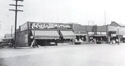
Biking was also popular before the War, as evidenced by the fact that a popular bicycle repair shop (Mr. Ellis’s Repair Shop) used to exist on Beacon Avenue at the current location of La Bendicion. Because it was difficult to get off the Hill by foot, bike, or long street car ride, people stayed up here to do their shopping and the local economy boomed. Today, the Department of Planning and Development‘s answer to bolstering the local economy is density and transit oriented development. Generating more shoppers will help, but just as important is to reorient existing residents inward. One way of doing this is changing how we get around.
So before I walk up to Red Apple to get some groceries, and El Centro to pick up my Christmas tree, I thought I would share another quasi-local route to a great shopping destination that is fun for the whole family: Goodwill!
This route is safe for bikers of any level and because it uses 18th Avenue South to get back up the hill, it is not too strenuous.  I look forward to the days when I can stay on the Hill to do all my shopping; until then, I have my bike as a viable transportation alternative that forces me to keep it local (and keeps me from getting trampled trying to pick up a NERF N-Strike™ Stampede ECS™). Happy Holidays and please respond with your favorite local shopping destinations!
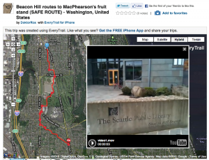
Beacon Hill to Goodwill on Dearborn (SAFE ROUTE) at EveryTrail

* * *
The Seattle Department of Transportation wants to know “what you think about transit in Seattle and how it could be better.” You can tell them by taking their survey. It’s fairly short.
And speaking of SDOT, The SDOT Blog has some pictures of the newly spiffed-up South Columbian Way.
* * *
Andrew Matson of The Seattle Times features rapper Nacho Picasso of Beacon Hill’s Cloud Nice hip-hop collective. There is a sound clip and a link to download even more. The Cloud Nice page also has a link to a Nice Dreams trailer with some Beacon Hill-area footage.
* * *
You might have noticed sheep baa-ing somewhere on Beacon Hill lately.
* * *
Dylan Ahearn mentioned it the other day, but here’s a reminder: Tomorrow (Saturday) is the Walk & Bike Beacon Hill Neighborhood Transportation Summit. It’s a neighborhood meeting to discuss ways to improve safety and mobility while walking and biking on Beacon Hill. The event is from 10:00 am to noon at Beacon Hill International School, 2025 14th Avenue South. Activities will include designing safe walking and biking routes, learning about bike safety for children, and more. Refreshments will be served. All ages are welcome. For more information, please contact Frederica Merrell, frmerrel@seattleschools.org.
* * *
If you’re already thinking ahead to Christmas, you might want to get your Christmas tree right here in the neighborhood. No, don’t chop one down in the Cheasty Greenbelt, please. Instead, you can get one from El Centro de la Raza. Trees will be available at their lot Wednesday through Sunday, starting November 26 and running through December 19. Order before the 26th and there will be a discount. There will be 2′-7′ Grand and Noble Firs, live trees, and 20″ and 30″ wreaths. Purchases will support El Centro’s many programs. El Centro is located at 2524 16th Avenue South.
Many years ago I lived in Davis, California, which is known as the biking capital of the U.S. (Their city logo is even a bike!). In Davis, biking is just the easiest way to get around, not only because it is a dense city and flat as a pancake, but because there is an amazing bicycle infrastructure to keep biking safe for everyone. As a result, 17 percent of the population commutes by bike (compared with the less than 3 percent in Seattle). I bring up Davis because what is interesting to see is that when that many people are biking, they stop identifying as cyclists—they are just people who happen to get around town in the easiest manner available, by bike. So that is our goal at Beacon BIKES!, to make biking so safe and easy that even your grandma will want to hop on a bike to head to MacPherson’s for her afternoon errands.Â
We are not a bunch of spandex-clad aggro bike advocates, but rather neighbors who want to see you on the streets walking or biking to your local destinations. If we get out of our cars (and yes, we all have cars too) more often, our options for what are viable trips change and we become more neighborhood-oriented. We go to Red Apple instead of Safeway, The Station instead of Starbucks, and we see our neighbors along the way!
Part of what we will be doing on the 20th is providing maps for safe routes to schools (and other destinations) for you and your children on Beacon Hill. We will have a bunch of blank maps; you show us where you live, and we draw you a safe route to your destination of choice. In the spirit of this, I have begun to compile a series of virtual tours of routes that I use to safely get around and off of Beacon Hill, both by myself and with my family. All the routes I map either start or end at the library or light rail station.
I use the program Everytrail to map all the routes. Here are my preferred routes to MacPherson’s (family-friendly) and Lowe’s (mostly safe, but involves biking on South College Street for a couple blocks). Clicking on these links will take you to the Everytrail website (click on the “View Full Screen” button on the bottom right of the map to get the best view of the route). For all the routes I use the following criteria:
I also frequently take advantage of the light rail to get back up the hill after biking off the hill. I have more routes already mapped and more planned for future posts. In the meantime, let me know the destinations you would like mapped in the comments section. Happy Biking! See you on Saturday!
On July 7, Mark Holland and I (representing Beacon BIKES) met with Seattle Department of Transportation (SDOT) and Sound Transit to discuss options for improving the pedestrian crossing in front of the light rail station. As it currently stands the crossing is not very safe. The crossing distance is very long, people do not use the crosswalks, traffic moves too fast, and the bus stops complicate the foot and vehicular traffic patterns. Add to this the surge of people coming from the light rail station and we have an accident waiting to happen. You can see a previous post about the dangers of the crossing here.
Sound Transit was planning to repave the section of Beacon between McClellan and Lander without improving the pedestrian crossing. Beacon BIKES got wind of this and arranged a meeting to discuss options for pedestrian improvements as part of the repave. SDOT was instrumental in setting up the meeting and convincing Sound Transit that this crossing needed to be improved (Thanks Sam Woods!!). Based on our meeting SDOT came up with the following design.
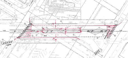
The major features of the new design are a planted median, widened crosswalks at either end of the block, and narrowed travel lanes. The narrowed lanes would mean that buses stop in lane. In lane bus stops are being implemented all over the city as a means of speeding up the bus system. The median would have a tasteful barrier down the middle so people could not stream across the street at mid block. Instead, they would be directed to the wide crosswalks at the corners to cross. With the widened sidewalks the crossing distance would be shortened making for a safer pedestrian experience.
The design that Beacon BIKES put forward did not have in lane bus stops but did include a raised crosswalk at mid-block. Our logic here was that everyone wants to cross at mid-block to get to the bus, so why not give them an avenue to do that instead of forcing them around (also the raised crosswalk would act as a speed table and slow traffic down). SDOT did not like the mid-block crossing idea because of the relatively short distance between McClellan and Lander, but we are still hoping they will reconsider. 🙂
As is apparent from the rough nature of the design sheet, the plan is not finalized, so this is your chance to come up with an inspired idea that will make this pedestrian crossing safe and inviting while still accommodating bus, bike, and vehicle traffic.
In the meantime check out Beacon BIKES on Facebook, and come to our next meeting to join the fun. The meeting is on Monday, November 15, at the Beacon Hill Library, 2821 Beacon Avenue South.
The sale hours are 8:00 am to 3:00 pm both days. St. George is located at 5117 13th Avenue South.
As always, you can keep up with Beacon Hill events on our Events page.
As many of you know, there is a growing movement among Beacon Hill residents interested in safely getting people of all ages and abilities around and to destinations within our neighborhood on foot and bicycle. This propelled Beacon BIKES!, a growing group of community members, to obtain the knowledge and expertise of a consultant to bring our collective vision to fruition. (Links available describing some of our ideas can be found on the September 3rd posting on this blog.)
Friday, we chose Alta Planning + Design as our consultant from among three enthusiastic applicants. Beacon BIKES! believes that pedestrians and cyclists encounter similar obstacles in getting around our neighborhood and that facilities that address both modes make the most sense. This philosophy is in line with Alta’s belief in “integrating all modes of travel (including walking and bicycling) into the daily lives of residents and creating healthy, safe, and sustainable communities.â€Â Most importantly, they offer an interactive approach geared to keeping the neighborhood informed and involved throughout the process.
All this is great news, but in order for this to work, we’ll need anyone and everyone to chime in at our monthly Beacon BIKES! meetings to make this a uniquely Beacon Hill plan. The next meeting will be held at the community room of the Library at 6:30 PM on Monday, September 13th. SDOT representatives will be in attendance, so the more Beaconites there, the more seriously our work will be taken. If you’re not involved already, you will want to be after this meeting!
In addition, there will be opportunities to participate through community forums, walks and other interactive outings to make this circulation plan for us and by us.
As always, you can prepare for the next Beacon BIKES! Family Bike and Pedestrian Circulation Plan meeting by visiting our Facebook page: Beacon BIKES!
You may also contact Sandra Woods or Brian Dougherty of SDOT and our City Council members to let them know you are a participant in and support our Family Bike and Pedestrian Circulation Plan.
Be sure to check back to the blog for updates. We hope to see many of you at the meeting.
Thanks Beacon Hill!
* * *
It’s been all over the local news, but we thought we’d mention it too. Long-time Seattle institution Dick’s Drive-in is hosting a poll on their website, asking where they should build a new Dick’s—north of Seattle, South Seattle (as far south as SeaTac), or the Eastside? Now, we know that Beacon Hill itself wouldn’t be a good location for Dick’s. But we think that a new Dick’s location would fit perfectly into, say, Sodo. We would also like to point out that every single existing Dick’s location is already north of Downtown (though Broadway is only slightly north) and it’s time to give South Seattle some love—and some chocolate milkshakes. Currently we are in second place with 29%, and the north end is running away with the election. Go here to vote.
* * *
If you prefer coffee to a Dick’s milkshake, fear not—Victrola has begun a weekly “cupping” (coffee tasting) at their Beacon Hill location, every Saturday at noon. The café is located at 3215 Beacon Avenue South. — Coffee City blog at The Seattle Times
* * *
Jessie McKenna of ROCKiT space sent along an announcement:
Just a quick announcement that as many of you know, Suzanne Sumi will be taking over Kids’ Dance, Sing & Play. The classes are weekly on Wednesdays, will begin at 9am and are one hour sessions.
The cost is still just $5 per class, but is per family, not per child. This class is big fun for toddler/pre-school aged children and you will just LOVE Suzanne. She’s wonderful! She has 26 years of early childhood education under her belt and will share stories, songs and more with you and your children.
Hope to see you with kids in tow some Wednesday soon!
We see also on their website that ROCKiT space is offering $5 Spanish language classes for both kids and adults, beginning Saturday, September 11. Find out more on the site.
ROCKiT space is at 3315 Beacon Avenue South. Please note that they will be closed from Sunday September 5 through Sunday September 12.
* * *
Publicola and Seattle Transit Blog recently ran articles praising Beacon Bikes! and noting that the group has been awarded $15,000 to make biking safer in the neighborhood.
Way to go, Dylan and Beacon Bikes! (Check out the Beacon Bikes! Facebook page.)
* * *
Publicola reported a while back that loss of the city’s tree canopy is worst in Southeast Seattle, including part of Beacon Hill. The city is hosting an Urban Forestry open house on September 21 to discuss city plans and proposals to increase and enhance our urban forest. More information about the open house here.
* * *
Have a great Labor Day weekend and enjoy what remains of our very odd summer this year!
(Melissa Jonas also contributed to writing this edition of Beacon Bits. Thanks, Melissa!)

15th Avenue South between South Bradford Street and South Oregon Street (the red line on the map below) currently consists of four travel lanes with parking restricted at the morning and evening peak rush hour. Motor vehicles often travel significantly faster through this corridor than the speed limit of 30 mph. SDOT is proposing to remove on-street parking from both sides of the street, remove one northbound travel lane, widen the travel lanes and install dedicated bike lanes in both directions.
15th Avenue South between South Oregon Street and Swift Avenue South (the green line on the map) currently consists of one travel lane in each direction with parking on both sides of the street. There are marked school crosswalks at South Dawson Street and South Shelton Street for Maple Elementary School and St. George School as well as a school speed zone for Cleveland High School. SDOT is proposing a combination of a bicycle lanes where the road is uphill and sharrows where the road is flat or downhill. On-street parking would be removed from the east side of the street between South Lucile Street and South Dawson Street, and from the west side between South Dawson Street and South Angeline Street. Removing street parking in this alternating fashion will provide some traffic calming at the school crosswalks.
South Columbian Way between Beacon Avenue South and South Alaska Street (the blue line on the map) currently consists of four travel lanes. SDOT is proposing to remove one downhill lane and install dedicated bicycle lanes in both directions.
These proposals, when completed, will create continuous bike facilities from downtown Seattle and North Beacon to Mercer Middle School, Cleveland High School, Mid-Beacon Hill and Columbia City. If approved, these changes would be implemented in 2010. This project is funded by the “Bridging the Gap” transportation levy approved by Seattle voters in 2006.
You are invited to stop by the Open House and view project plans, provide feedback and chat with the project team. The event is Tuesday, August 24 from 5:00 – 7:00 pm at the Jefferson Community Center Meeting Room, 3801 Beacon Avenue South. You may also email your comments to walkandbike@seattle.gov or call 206-684-7583.
(Much of this article is adapted from SDOT’s press release describing the project. Thanks to Peg Nielsen for sending it along.)
View “Complete Streets” changes in Mid-Beacon Hill in a larger map
Mayor Mike McGinn will be on Beacon Hill this coming Tuesday, May 11, at 2:00 pm for the announcement of the “Walk Bike Ride” Initiative supporting improved pedestrian, bicycle, and transit facilities and services “to make walking, biking, and riding transit the easiest ways to get around in Seattle.”
The event is scheduled for the Lander Festival Street at 16th Avenue South and South Lander Street, immediately north of Beacon Hill Station.
The Seattle Times (BHB news partners) discussed the “Walk Bike Ride” initiative, as did PubliCola and the Seattle Transit Blog.