Category Archives: History of the Hill

Beacon Lutheran Church to close

Beacon Lutheran Church under construction in 1947. Photo courtesy of Beacon Lutheran Church archives via John Graham.
The 70-year-old Beacon Lutheran Church (1720 S. Forest St.) will close at the end of this month, with a final worship service and farewell dinner planned for Sunday, October 30. Community members are invited to the closing events.

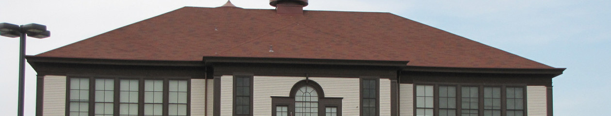
The church was founded in 1941 by members of Hope Lutheran Church in West Seattle. For the first few years, the group met at the Garden House on 15th Avenue South, then moved into their current building on South Forest Street in 1948.

Membership numbers have been gradually declining since the early 1970s, and so in March of this year, the congregation voted to disband, as the smaller membership could no longer keep the church functioning.

Ownership of the building and its contents will be transferred to the Northwest District of the Lutheran Church-Missouri Synod. The Rainier Valley Cooperative Preschool, which currently rents space in the building, will continue to rent there through at least the end of this school year. Long-term plans for the site are unknown.

John Graham sent us this invitation to the community:

You, our Beacon Hill neighbors, are all invited to the closing service and farewell dinner for Beacon Lutheran Church on Sunday, October 30th, 2011. Worship will begin at 10:00 am for the event. Afterwards, about noon-ish, we’ll gather for a potluck dinner and brief program to celebrate 70 years of God’s blessings to our congregation. There will also be photographs on display and hopefully, we can get a reminiscence or two out of our older members. Please come and share in one or both parts of the event. For more info, you can e-mail me at hamburgerclan@yahoo.com.

On behalf of the congregation, I’d like to thank you all for letting us be a part of the community on Beacon Hill. God’s richest blessings to you all in the years to come.

Peace,
John Graham

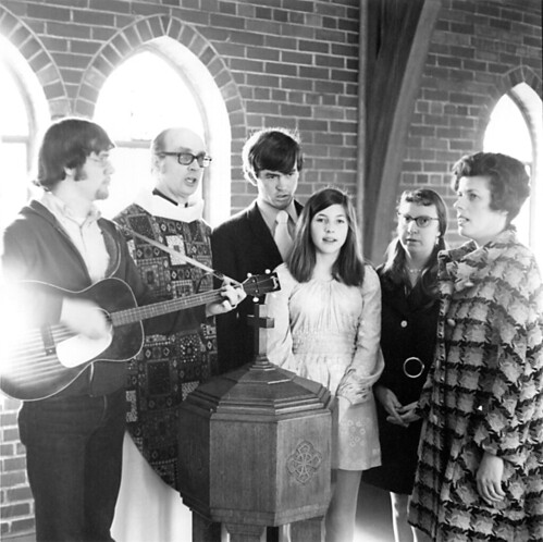
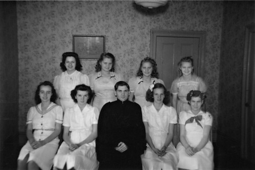
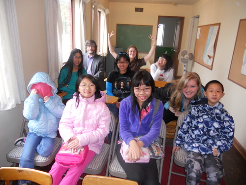
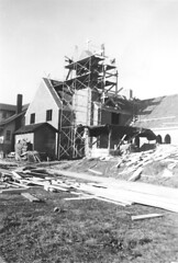
Here are some photos from the 70-year history of Beacon Lutheran Church.

Music during a worship service at Beacon Lutheran in about 1970. Photo courtesy of Beacon Lutheran Church archives via John Graham.
Beacon Lutheran Church's first confirmation class at the Garden Club House, 1942. Photo courtesy of Beacon Lutheran Church archives via John Graham.
Sunday School, January 2011. Photo courtesy of Beacon Lutheran Church archives via John Graham.

Past and present: Beacon Avenue streetlights

Beacon Avenue South, looking northward from roughly Beacon and Stevens, February 24, 1955. The photo was intended to show the street lights. Photo courtesy of Seattle Municipal Archives.
Nearly the same shot, taken on January 11, 2011 in the falling snow. Photo by Wendi.

It was difficult to match this image exactly because, though you can’t see from the photo, the snow was falling heavily and the photographer’s fingers were freezing. However, they are a fairly close match.

The Mobil Station on the left is now an auto repair shop that looks quite different, but if you walk by and look behind the building, you can see an old Mobil “Red Pegasus” sign. The house beyond the Mobil station is now the Beacon Hill Library. The sign on the corner that advertised the Mobil is in the same location today, and may be the same structure.

The trees that now grace the planting strip on the east side of Beacon, as large as they are now, weren’t there at all in 1955.

The trolley wires are still intact for the use of Beacon Hill’s trolleybuses.

Local holiday shopping by bicycle

Now that the holiday season is upon us, shopping is on the minds of many.  Black Friday is infamous for the crushing crowds at the box stores and the malls and now “Cyber Monday” has become a major phenomenon, as folks turn to the internet for convenient holiday shopping.  Both these forms have shopping have something in common: they do not support local businesses.  On Beacon Hill this is a chicken and egg issue—not much holiday shopping occurs locally because there are not many places to shop, and there are not many places to buy gifts because people tend to drive elsewhere to do their holiday shopping. But it was not always this way.

I was curled up with Images of America: Seattle’s Beacon Hill yesterday and came across this quote from Pete Caso (born 1923):  “There were many businesses before and now there is absolutely nothing. There were four drugstores on Beacon Hill, three bakeries, five grocery stores, and all your daily shopping was done on Beacon Hill. Why did the businesses close? The businesses were there in the 1940s. They closed up after World War II, with supermalls and everybody got a car. Before those days, nobody had a car. Up until then you used the street car or you walked.”

In 1937, the east side of the 15th and Beacon Junction, now home to the ABC Supermarket and the big empty building that is Hui Intertrading, was home to Eba's Mutual Grocery, Ray's Barbershop, a hardware store, and a small Safeway. Photo from the Puget Sound Regional Archives.

Biking was also popular before the War, as evidenced by the fact that a popular bicycle repair shop (Mr. Ellis’s Repair Shop) used to exist on Beacon Avenue at the current location of La Bendicion.  Because it was difficult to get off the Hill by foot, bike, or long street car ride, people stayed up here to do their shopping and the local economy boomed.  Today, the Department of Planning and Development‘s answer to bolstering the local economy is density and transit oriented development. Generating more shoppers will help, but just as important is to reorient existing residents inward.  One way of doing this is changing how we get around.

So before I walk up to Red Apple to get some groceries, and El Centro to pick up my Christmas tree, I thought I would share another quasi-local route to a great shopping destination that is fun for the whole family: Goodwill!

This route is safe for bikers of any level and because it uses 18th Avenue South to get back up the hill, it is not too strenuous.   I look forward to the days when I can stay on the Hill to do all my shopping; until then, I have my bike as a viable transportation alternative that forces me to keep it local (and keeps me from getting trampled trying to pick up a NERF N-Strike™ Stampede ECS™). Happy Holidays and please respond with your favorite local shopping destinations!

Beacon Hill to Goodwill on Dearborn (SAFE ROUTE) at EveryTrail

Past and present: Chickens in the basement

The old Fire Station No. 13 at 14th Avenue South and South Massachusetts Street, about 1915. Photo from the PEMCO Webster and Stevens Collection, MOHAI. Used by permission.
The old fire station building still exists, with some changes. Photo by Wendi.

This early 20th century firehouse on 14th avenue still remains, camouflaged as a residential building. Look closely at the dormer on the roof and you can see siding that matches the siding in the 1915 picture. Other details have been changed over the years, but the building is still clearly recognizable as old Station 13.

My attention was drawn to the building by this interesting letter posted in the Seattle Municipal Archives Flickr Feed:

Image courtesy of Seattle Municipal Archives.

Fire stations back then had to house horses, so the manure storage issues are not surprising. But the chickens in the basement were apparently not expected in a proper firehouse.

Fire Station 13 opened at 14th and Massachusetts on October 10, 1904, in what was, at that time, the center of Beacon Hill’s residential neighborhood. Over the next couple of decades, development on the Hill shifted further south, and the Fire Department changed from using horses to using motorized vehicles. These changes necessitated the building of a new station that would be more centrally located to serve Beacon Hill, and more suitable for the new vehicles. The old firehouse remained in service until the new station opened at the intersection of Beacon Avenue South and South Spokane Street in 1928. That building is a Seattle historical landmark that remains in operation as a fire station to this day.

The current Station 13, opened in 1928. Photo by Jason.

Jefferson Park, the missing jewel

by Joel Lee

Workers busy last week putting some of the new features in the park. Photo by kashgroves in the Beacon Hill Blog photo pool on Flickr.
On April 30, 1903, Seattle leaders hired the prominent Olmsted Brothers, one of the first and most important landscape architecture firms in the country, to design a park and boulevard system for Seattle. On October 19, 1903, Charles Olmsted wrote of the Seattle park system that the “primary aim should be to secure and preserve for the use of the people as much as possible of these advantages of water and mountain views and of woodlands, well distributed and conveniently located.” Beacon Hill’s Jefferson Park was one of a handful of parks that the Olmsteds considered vital to the success of their plan and the health of the city, and joined a short list of important parks including Seward Park, Green Lake, the Arboretum, and Volunteer Park as key links in an “emerald necklace” of parks and boulevards connecting the city.

A new viewpoint shows the autumn foliage from Jefferson Park. Photo by Joel Lee.
Unfortunately Jefferson Park’s history has been more convoluted than these other parks, and the Park has gone through many changes over the years since the land was first purchased by the city in 1898. Named after President Thomas Jefferson, the area was used for everything from a “pesthouse” isolating smallpox patients, to military use, housing anti-aircraft guns and a G.I. recreation center when the land was requisitioned during World War II.

A large northwest section of the park was turned over to the water department where, until recently, it housed the two above-ground water reservoirs built a hundred years ago. This had the unfortunate side effect of taking what had been a key open green space and community gathering spot on Beacon Hill and converting it to a fenced-off barbed wire government compound which served as a physical barrier dividing the neighborhood.

Soon, however, the fences are coming down and once again Beacon Hill will be united. At 52.4 acres, Jefferson Park and its accompanying golf course are one of Seattle’s largest parks. Although some of the key components to the park such as the skate park and the Beacon Mountain Playground are not yet complete, it is already easily one of the nicest parks in the city. With its well-planned walkways and playfields taking advantage of the stunning views of downtown and Elliott Bay, it is easy to imagine how this area is going to become Beacon Hill’s new outdoor living room and one of the best green spaces in the Seattle park system. Perhaps more importantly, it will finally complete the plan that the Olmsted Brothers put into place over 100 years ago to unite Seattle with an “emerald necklace” of parks and boulevards, and bring Beacon Hill together with the rest of the city.

Joel Lee maintains the Beacon Hill Public Art website.

Got something to say? We welcome articles on topics related to Beacon Hill. Please email us your ideas.

A celebration in the Army Recreation Center, Jefferson Park, 1943. Courtesy of the Seattle Municipal Archives via Joel Lee.

Beacon Reservoir Gatehouse to be mothballed

Seattle Public Utilities released the statement below on the landmark-nominated Beacon Reservoir Gatehouse at Jefferson Park.

Seattle Public Utilities (SPU) has determined, through rigorous business case analysis, that the most cost-effective solution for the Beacon Hill Reservoir Gatehouse is to mothball the building and perform routine maintenance as required in its mothballed condition.

The mothballing approach preserves the opportunity for making future improvements to the gatehouse. It mainly consists of safe removal of dangerous lead-containing coating on the exterior walls and applying a new application of aesthetic paints around the gatehouse.

SPU will review the gatehouse mothball status as part of its routine three-year maintenance planning cycle.

Mothballing tasks will begin in early 2011, in coordination with the Parks Department Jefferson Park project team.

Roberto Maestas, El Centro founder, dies

Roberto Maestas, a founder of Beacon Hill’s El Centro de la Raza who led that non-profit organization until he retired last year, passed away this morning of lung cancer at the age of 72.

Mayor McGinn has ordered that city flags be lowered to half-staff today in honor of Maestas.

A former Spanish teacher at Franklin High School, Maestas was among the activists involved in the peaceful occupation of the then-empty Beacon Hill Elementary School building on 16th Avenue South in 1972. After three wintery months in the run-down building, the group negotiated an agreement with the City to lease the building for $1 per year, and the El Centro organization has been there ever since. Maestas led the organization as executive director until he stepped down in 2009.

The Seattle Civil Rights and Labor History Project at the University of Washington has this page about Maestas, including a biography and several video interviews.

Here is a story from last year about the Four Amigos: Maestas, the late Bernie Whitebear, Larry Gossett, and Bob Santos, who as activists and friends worked together to make Seattle a more just place.

The Seattle Times (BHB news partners) posted an obituary here. More obits at KIRO TV, Seattle P-I, Seattle Weekly, and The Stranger.

Update: Details of a memorial celebration for Mr. Maestas are in the comments.

Beacon Reservoir Gatehouse nominated as landmark

The Beacon Reservoir Gatehouse, as pictured here in the Landmark Nomination Application, has seen better days. Photo: Seattle Department of Neighborhoods.
Neighbors working to save the Beacon Reservoir Gatehouse are seeing progress. The Landmarks Preservation Board will consider the nomination of the gatehouse (3801 Beacon Avenue South, inside Jefferson Park) at its upcoming meeting. (This is the official address, but the actual Gatehouse location is much closer to 15th Avenue.) BHB formerly reported on the gatehouse here.

The public is invited to attend the meeting and make comments. It’s scheduled for Wednesday, September 1 at 3:30 p.m. in the Seattle Municipal Tower, 700 Fifth Avenue, 40th Floor, Room 4060.

Written comments should be received by the Landmarks Preservation Board at the following address by 5:00 pm on August 31: Seattle Landmarks Preservation Board, Dept. of Neighborhoods, P.O. Box 94649, Seattle WA 98124-4649.

Copies of the landmark nomination are available for public review at the Beacon Hill Branch Library, 2821 Beacon Avenue South.  The nomination is also posted on the Department of Neighborhoods website.

Photo: Seattle Department of Neighborhoods.

The view from Beacon Hill in 1949

We recently posted a couple of photos of the view from Beacon Hill in 1959 and today. Burr Cline (Cleveland High School class of ’47) contacted us with a similar photo taken in 1949, and this one’s in color! There are fascinating details in it — billboards, cars, buildings that still exist and buildings that don’t. The color is amazingly true for a 60 year old image.

Please click on this image to see the large version.

Thanks to Burr for sending us this wonderful view!

Jose Rizal bridge repairs, then and now

The Jose Rizal Bridge rehab project is starting soon, and to facilitate this work, traffic on the bridge will be reduced to one lane in each direction for the next four months. A sidewalk on one side of the bridge at a time will be closed, and access for pedestrians and bicycles will be maintained on the opposite side. There will also be periodic lane closures on South Dearborn Street under the bridge.

The Rizal bridge was also a topic on the Seattle Municipal Archives photostream on Flickr yesterday, when this photo was posted:

Photo courtesy of Seattle Municipal Archives.

This is probably a photo of the 12th Avenue South Bridge (now Jose Rizal Bridge) in spring 1917, when a mudslide destroyed the southern (wooden) approach to the bridge. The bridge was later repaired. The Jose Rizal bridge was built in 1911, and is the oldest steel-arch bridge in Washington state. This 1912 photo shows the familiar shape of the bridge that many of us cross daily.